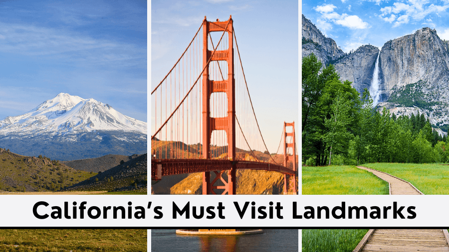
Towering granite cliffs, thundering waterfalls, and some of the most jaw-dropping mountain scenery in the United States are all waiting for you in Yosemite National Park.
If you’re wondering where to start, this road trip itinerary guides you through the park’s most unforgettable landscapes, from valley floors to high-elevation viewpoints.
Along the way, you’ll discover places shaped by glaciers and explore scenic roads that reveal a new breathtaking view around nearly every corner.
Whether you have one day or several, here’s how to make the most of your Yosemite adventure and see why millions of people return to this incredible national park year after year.
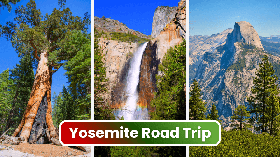
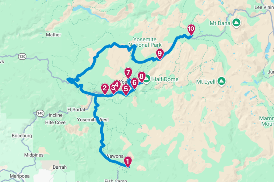
1. Mariposa Grove of Giant Sequoias
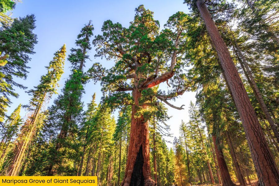
Mariposa Grove of Giant Sequoias, near Yosemite’s South Entrance, is home to 500 mature giant sequoias, including the Grizzly Giant, estimated to be 2,700 years old.
Another must-see is the California Tunnel Tree, an enormous giant with a tunnel carved through its trunk in 1895 that you can walk through today.
These are among the largest trees on Earth, with some trunks measuring about 30 feet in diameter, so take your time admiring them.
To make the most of your visit, hike one of the grove’s popular trails, from the easy 0.3-mile Big Trees Loop Trail to the longer 7-mile Mariposa Grove Trail.
2. Tunnel View
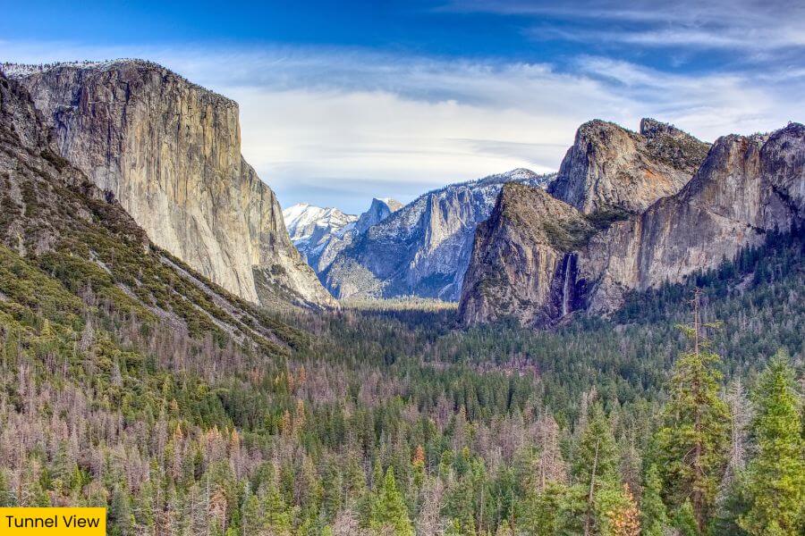
After wandering among the trees, head to Tunnel View, Yosemite’s most famous overlook, located along State Route 41 just outside the Wawona Tunnel.
From here, you’ll see El Capitan towering on the left, Bridalveil Fall on the right, and Half Dome rising nearly 5,000 feet above Yosemite Valley in the distance.
It’s one of the most photographed spots in the park, and chances are you’ve already seen this exact view on postcards, calendars, and travel magazines.
For the most dramatic views, visit at sunrise or sunset, when changing light paints the granite walls in shades of gold, pink, and orange.
3. Bridalveil Fall
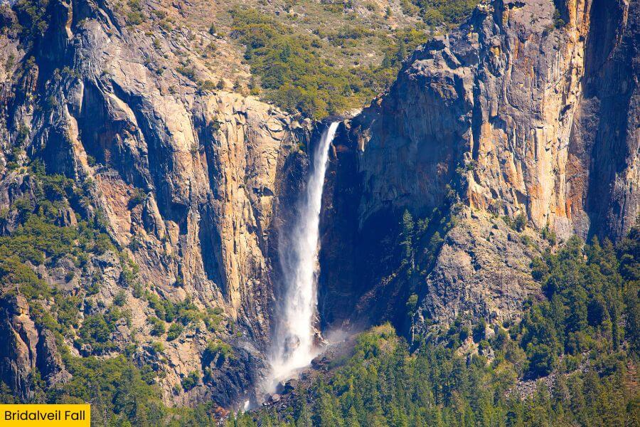
From Tunnel View, it’s a 5-minute drive to Bridalveil Fall, one of Yosemite’s most iconic waterfalls and one of the first major sights you’ll see when entering Yosemite Valley.
It plunges 620 feet down a granite cliff, and spring snowmelt turns it into a spectacular rush of water crashing into the rocks below.
To get a closer look, follow the 0.5-mile round-trip trail from the parking area to the base, where mist often fills the air and can leave you completely soaked on windy days.
The fall flows year-round, making it one of Yosemite’s most reliable waterfalls, and its misty cascade makes a stunning backdrop for photos.
4. El Capitan Meadow
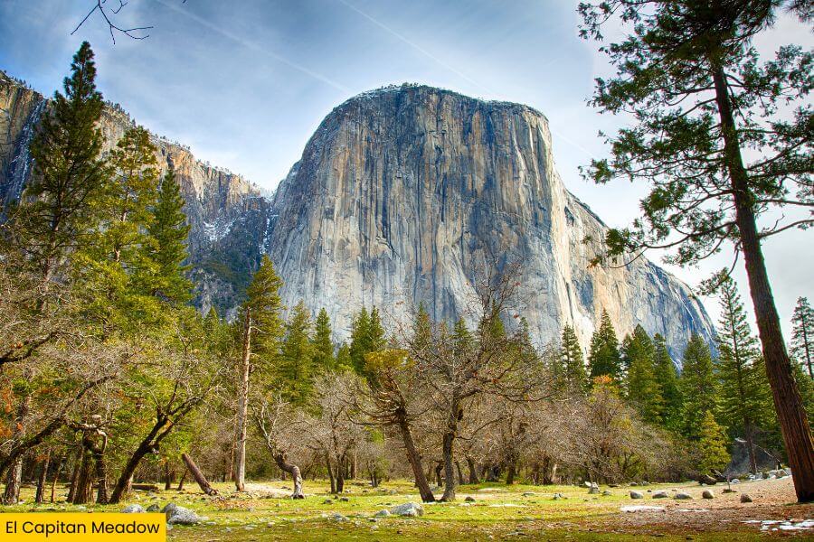
Just a 10-minute drive from Bridalveil Fall is El Capitan Meadow, one of the best places in Yosemite to admire the park’s most famous granite giant.
This place sits directly below El Capitan, the massive formation that rises about 3,000 feet from the valley floor and draws elite climbers from around the world.
Bring binoculars and look closely at the rock face, especially around sunset, when climbers’ headlamps begin to appear across the cliff like stars.
It’s one of those spots that makes you feel incredibly small as you take in the sheer size of the cliff above.
5. Taft Point
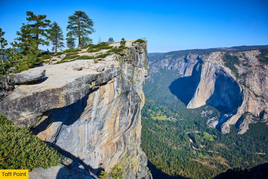
Once you’ve admired El Capitan, drive about 45 minutes to Taft Point, a dramatic overlook located along Glacier Point Road high above Yosemite Valley.
Reaching it requires a 2.2-mile round-trip hike with about 200 feet of elevation gain, taking you through a forest and past The Fissures along the way.
These striking granite fissures are deep cracks in the rock that reveal dizzying views straight down to the valley floor.
Afterwards, continue to the fenced overlook at Taft Point, where stunning views of El Capitan and Yosemite Falls make the hike well worth the effort.
6. Glacier Point
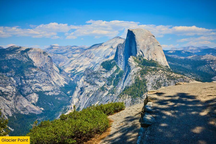
If you’re up for another spectacular viewpoint, continue along Glacier Point Road to Glacier Point, which sits 7,214 feet above sea level.
It also sits about 3,200 feet above Half Dome Village, giving you a bird’s-eye perspective that makes even Yosemite’s massive landmarks look surprisingly small.
The view stretches across Half Dome, Yosemite Falls, Nevada Fall, Vernal Fall, and Clouds Rest, all set against a backdrop of towering cliffs and forested peaks.
Sunrise and sunset are especially memorable here, when warm light washes over the landscape and creates a picture-perfect scene.
7. Yosemite Falls
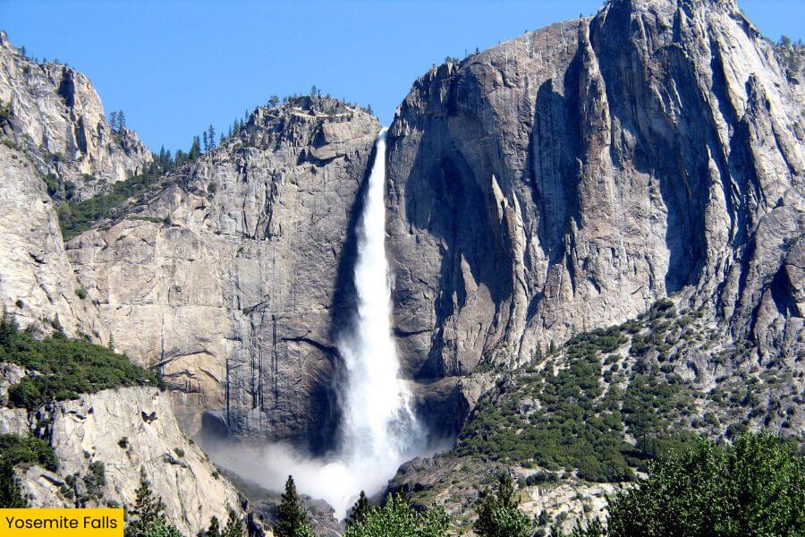
Your next stop is Yosemite Falls, one of the tallest waterfalls in North America and a highlight of any visit to Yosemite, about an hour from Glacier Point.
This waterfall drops a staggering 2,425 feet in three sections, including the 1,430-foot Upper Yosemite Fall, the middle cascades, and the 320-foot Lower Yosemite Fall.
To see it up close, follow the 1-mile loop trail to the base of Lower Yosemite Fall, where you can feel the roar of the water and catch refreshing spray during peak spring runoff.
If you’re up for a challenge, hike the strenuous 7.2-mile Yosemite Falls Trail, which gains about 2,700 feet in elevation and rewards you with sweeping views from the top.
8. Mirror Lake
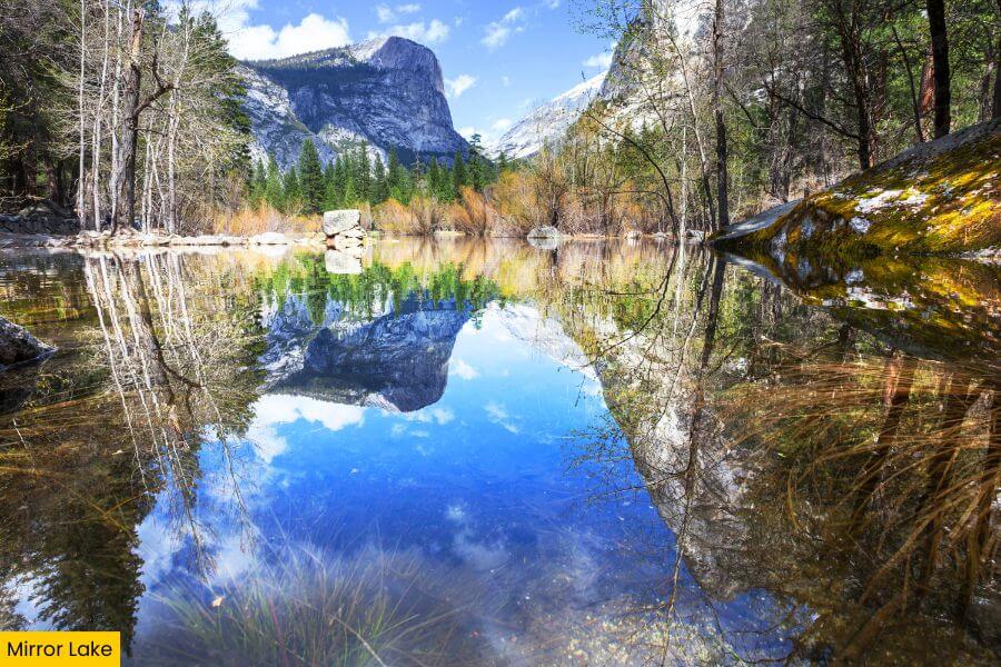
Now slow the pace with a walk to Mirror Lake, a peaceful spot on Tenaya Creek in Tenaya Canyon between Half Dome and North Dome.
You can reach it via a mostly paved 2-mile round-trip trail, or continue on a longer 5-mile loop that follows the creek through the valley.
During spring and early summer, the calm water creates beautiful reflections of the surrounding landscape, which is how Mirror Lake got its name.
These seasons are ideal for a visit, when the lake is at its fullest before gradually shrinking later in the year.
9. Olmsted Point
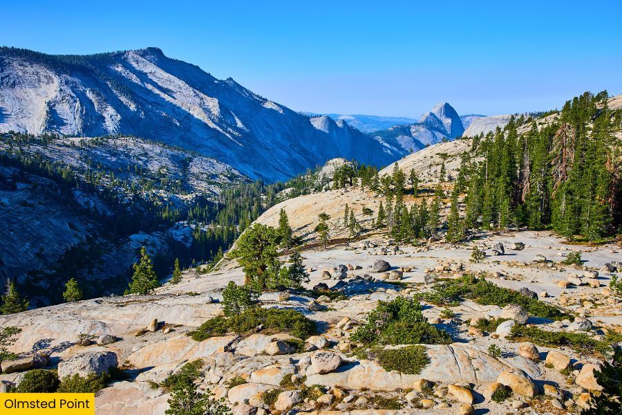
About 1 hour and 20 minutes from Mirror Lake is Olmsted Point along Tioga Road, a must-visit if you want to see Yosemite from a completely different angle.
Sitting at about 8,400 feet in elevation, this granite viewpoint looks out over the northern side of Half Dome, Tenaya Canyon, and Tenaya Lake.
You can admire the scenery from the roadside parking area or take a short 0.25-mile walk to the point, where you’ll pass glacial erratics left behind by ancient glaciers.
It’s one of the park’s most rewarding roadside stops, offering a peaceful break from the busier destinations earlier in the trip.
10. Tuolumne Meadows
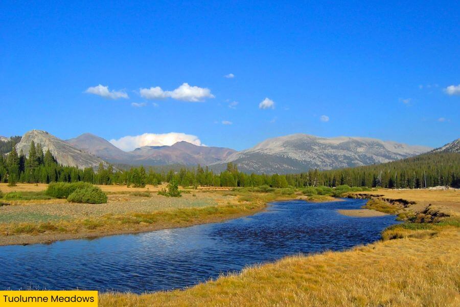
Also along Tioga Road is Tuolumne Meadows, just 15 minutes from Olmsted Point, one of the largest high-elevation meadows in the Sierra Nevada at 8,600 feet.
Stretching alongside the Tuolumne River, it is surrounded by granite domes and rugged peaks that create some of the park’s most spectacular scenery.
It’s also one of the area’s top hiking hubs, with popular trails leading to Cathedral Lakes and Lembert Dome, a 2.8-mile round-trip climb with panoramic views.
Make sure to keep an eye out for deer grazing in the meadow while you’re here, especially during the quiet morning and evening hours.
Related Posts