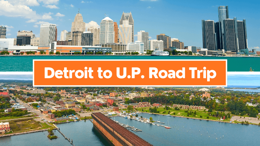
If you’re craving a road trip that packs in massive lakes, towering forests, and some seriously cool roadside stops, this Detroit to Upper Peninsula drive is about to be your new favorite route.
You’ll start in a buzzing city, then cruise through storybook-style towns, quiet stretches of shoreline, and forests filled with trees older than most cities in the U.S.

Along the way, expect everything from natural wonders to crystal-clear water so pure you can see straight to the bottom.
It’s the kind of trip where every stop feels completely different from the last, and just when you think it can’t get better, the next stretch of road proves you wrong.
1. Detroit

Detroit is known as the Motor City because Henry Ford started building cars here in the early 1900s, and you can still tour the massive Ford Rouge Factory where the F-150 is assembled.
You’ll find big-name spots like the Renaissance Center, a 727-foot-tall complex on the riverfront, plus the nearly 5-mile Detroit RiverWalk that’s packed with parks, views, and public art.

Music fans can step inside the Motown Museum at Hitsville U.S.A., where artists like Stevie Wonder and The Supremes recorded hits, while sports fans can catch a game at Comerica Park or Little Caesars Arena right downtown.
Please note that, at the time of writing, Hitsville U.S.A. has paused its public tours for a major expansion project that began in January 2026 and is planned to reopen in spring 2027.
2. Frankenmuth
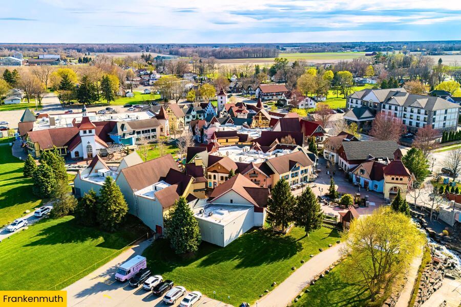
About 1 hour and 25 minutes from Detroit, Frankenmuth goes all-in on its Bavarian roots with half-timbered buildings, flower boxes, and streets that feel straight out of southern Germany.
This town is famous for Bronner’s Christmas Wonderland, the world’s largest Christmas store at 320,000 square feet, where you can shop for ornaments year-round and spot Santa out front.
Food is a huge deal here, and you’ll want to stop at Zehnder’s of Frankenmuth for all-you-can-eat family-style chicken dinners with buttery noodles, stuffing, and house-made bread.
If you’re up for some fresh air, stroll the River Place Shops area, hop on a Bavarian Belle riverboat cruise along the Cass River, or walk the Holz-Brücke Covered Bridge, which stretches 239 feet across the water and lights up beautifully at night.
3. Tawas Point State Park
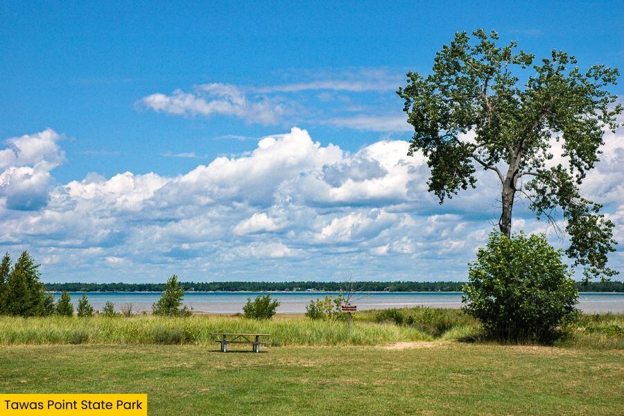
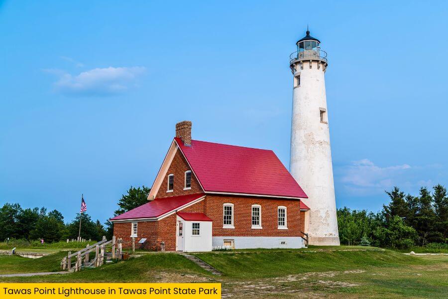
Keep driving for about 1 hour and 40 minutes and you’ll hit Tawas Point State Park, a sandy stretch that juts 2 miles into Lake Huron and feels totally different from the Bavarian streets you just left behind.
This park is nicknamed the “Cape Cod of the Midwest” thanks to its curved shoreline, soft beaches, and the 1876 Tawas Point Lighthouse that still stands 67 feet tall near the tip.
You can walk the easy 1.5-mile Sandy Hook Nature Trail, swim in surprisingly shallow water that stays knee-deep for dozens of yards, or watch for more than 300 bird species during spring and fall migrations.
Stick around for sunset because the park faces west over Tawas Bay, giving you glowing orange skies over Lake Huron, which is a rare treat on Michigan’s east side.
4. Hartwick Pines State Park

Next, drive about 1 hour and 35 minutes to Hartwick Pines State Park, home to one of the last remaining old-growth pine forests in Michigan.
This park protects 49 acres of towering white pines that soar over 150 feet tall and are more than 300 years old, giving you a rare look at what Michigan looked like before the logging boom of the 1800s.

The 1.25-mile Old Growth Forest Trail is an easy loop with flat boardwalk sections, and it winds right through these massive trees along with quiet stretches of the Au Sable River.
You can also stop by the Logging Museum, which has full-size recreated camps and equipment that show how lumberjacks lived and worked during Michigan’s peak logging era in the late 19th century.
Please note that the Hartwick Pines Logging Museum operates seasonally, typically from May through September.
5. Mackinaw City

After the quiet forest, you’ll roll just over an hour to Mackinaw City, the spot where Michigan’s Lower Peninsula ends and the Straits of Mackinac begin.
This small town sits right at the base of the Mackinac Bridge, a 26,372-foot-long suspension bridge that stretches 5 miles across the water and connects you to the Upper Peninsula.

You can walk the Old Mackinac Point Lighthouse grounds, catch ferry boats heading to Mackinac Island, or explore Colonial Michilimackinac, an 18th-century fort reconstructed with original foundations.
Grab some fresh fudge from shops along South Huron Avenue, then head to the shoreline at sunset where you can watch freighters pass under the bridge while waves crash along the rocky edge of Lake Michigan and Lake Huron meeting.
6. Tahquamenon Falls State Park

Once you cross into the Upper Peninsula, keep driving about 1 hour and 35 minutes and you’ll land at Tahquamenon Falls State Park, one of the largest state parks in Michigan at nearly 50,000 acres.
The star here is the Upper Falls, which drop nearly 50 feet and stretch more than 200 feet wide, making it one of the biggest waterfalls east of the Mississippi River.

Follow the 0.4-mile paved trail to the main viewing platforms, or take the 4-mile River Trail to the Lower Falls, where a series of smaller cascades surround an island you can reach by rowboat ferry in summer.
The water gets its deep amber color from tannins released by cedar and hemlock trees upstream, and you can grab a locally brewed beer at the Tahquamenon Falls Brewery right near the Upper Falls parking area.
7. Kitch-iti-kipi
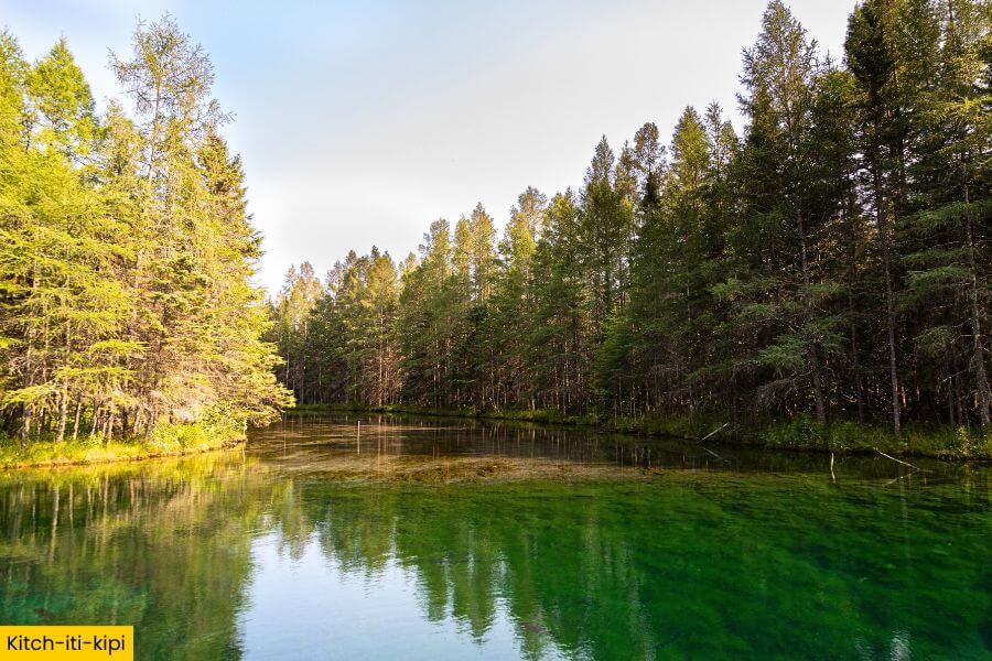
From the roaring waterfalls, slow things down at Kitch-iti-kipi in Palms Book State Park, a crystal-clear freshwater spring that feels almost unreal the second you see it.
This natural spring is 200 feet across and 40 feet deep, pushing out around 10,000 gallons of water per minute, which keeps it a steady 45 degrees year-round.

You’ll step onto a hand-pulled observation raft that glides across the surface, letting you look straight down at ancient tree trunks, lime-green sand, and constant bubbling springs below.
The name means “Big Cold Water” in Ojibwe, and once you see the bright turquoise water and perfect clarity, it’s easy to understand why this spot is one of the most unforgettable stops in the Upper Peninsula.
8. Pictured Rocks National Lakeshore

From there, it’s about an hour’s drive to Pictured Rocks National Lakeshore, a 42-mile stretch along Lake Superior where towering cliffs steal the show.
These sandstone cliffs rise up to 200 feet above the lake and are streaked with bold colors like red, orange, and green, created by minerals like iron and copper slowly seeping through the rock.
You can paddle past famous formations like Chapel Rock and Miners Castle on a guided kayak tour, or hike the 10.5-mile Chapel Loop Trail to see waterfalls like Chapel Falls dropping 60 feet into the forest.
For the best views, hop on a boat cruise from Munising that takes you right along the base of the cliffs, where you’ll pass sea caves, arches, and beaches that are only reachable by water.
9. Marquette
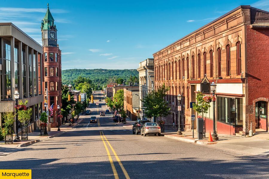
After soaking in those cliffside views, drive about 50 minutes to Marquette, the largest city in Michigan’s Upper Peninsula, set right on the southern shore of Lake Superior.
This laid-back college town is home to Northern Michigan University and mixes outdoor adventure with cool local spots like Blackrocks Brewery and the historic Landmark Inn, built in 1930.

You can hike the 0.5-mile Sugarloaf Mountain Trail for a sweeping view over Lake Superior, Presque Isle Park, and the surrounding forests.
Don’t miss Presque Isle Park itself, a 323-acre peninsula where you can walk the 2.2-mile loop road, watch waves crash at Black Rocks, or catch a glowing Lake Superior sunset that feels like the perfect send-off to your Upper Peninsula road trip.
Related Posts