If you’re planning a trip to Pictured Rocks National Lakeshore, get ready for a place that packs a ton of scenery into one unforgettable stretch of Lake Superior shoreline.
Think towering cliffs, waterfalls tucked into the forest, and scenic trails that lead to views you’ll be talking about long after your trip ends.
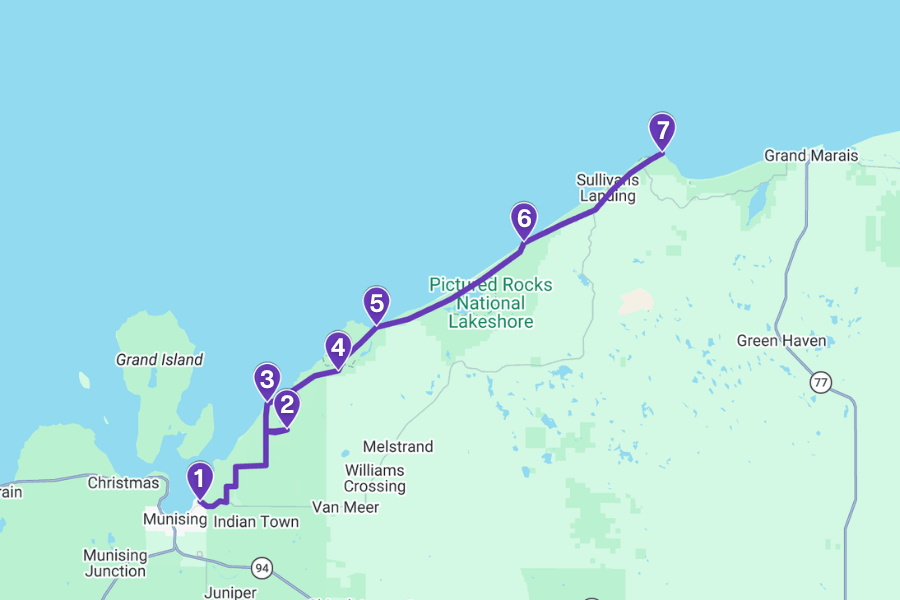
This itinerary is designed to help you hit the absolute must-see spots without wasting time zigzagging all over the park.
Expect short hikes, epic viewpoints, and a few surprises along the way that make this place way more than just a quick stop.
1. Munising Falls

Munising Falls is a 50-foot waterfall just a 5-minute drive from the town of Munising, and it’s one of the easiest must-see stops in the park.
To reach it, a short 0.4-mile out-and-back trail with stairs leads to viewing platforms where you can watch water pour over a sandstone cliff.
The upper viewing deck gives you a close-up look at the water as it spills over the edge, while the lower platform lets you feel the cool mist at the base.
If you visit in winter, it’s extra special as the falls freeze into massive ice curtains, turning the area into a natural ice-sculpture gallery perfect for photos.
(At the time of writing, the Munising Falls trail is temporarily closed because of recent heavy rain and snow, so make sure to check online for updates before planning your visit.)
2. Miners Falls
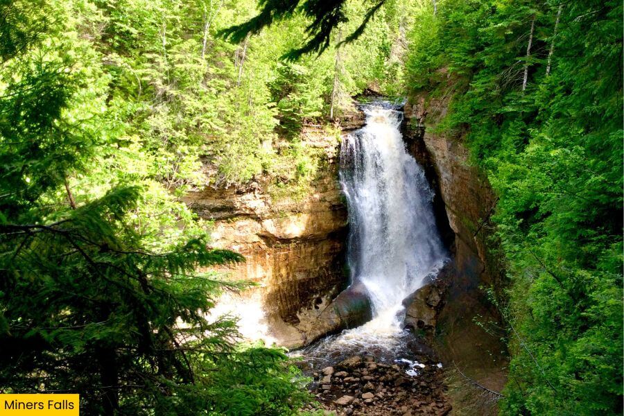
Next up, Miners Falls brings the drama with a 50-foot drop set deep in the forest.
This is where the Miners River crashes over a hard sandstone ledge and fans out into a wide curtain of water, which is especially powerful after heavy rain.
You need to take a 1.2-mile out-and-back trail to reach it, and the last stretch includes 64 steps down to a viewing platform with a perfect angle of the falls.
It’s a great spot to slow down, take in the scenery, and snap a few photos before heading to your next stop.
3. Miners Castle Overlook
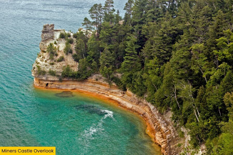
From there, head over to Miners Castle Overlook, the most famous rock formation in Pictured Rocks and the only one with a drive-up overlook.
You can explore multiple viewing platforms here, including two upper overlooks, while stairs lead down to a lower viewpoint, all accessible from the parking lot.
These spots put you face-to-face with towering sandstone cliffs above Lake Superior.
Fun fact: The formation gets its name from its castle-like shape, which once featured two turrets, though one collapsed in 2006, altering its overall look.
4. Mosquito Falls
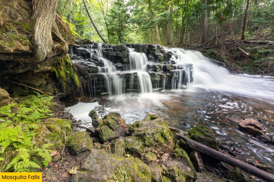
Keep the adventure going with Mosquito Falls, a quieter spot in the Chapel area that feels way more off the radar than the big-name stops.
It’s about a 2-mile round-trip hike from the Chapel parking lot, starting toward Mosquito Beach for 0.3 miles before turning onto a 0.7-mile side trail to the falls.
Once you reach it, you’ll see water spilling over an 8-foot rock shelf on the Mosquito River, creating a small but scenic cascade.
The extra effort to get here makes it feel more rewarding, turning it into more than just another stop along the way.
5. Chapel Rock & Chapel Beach
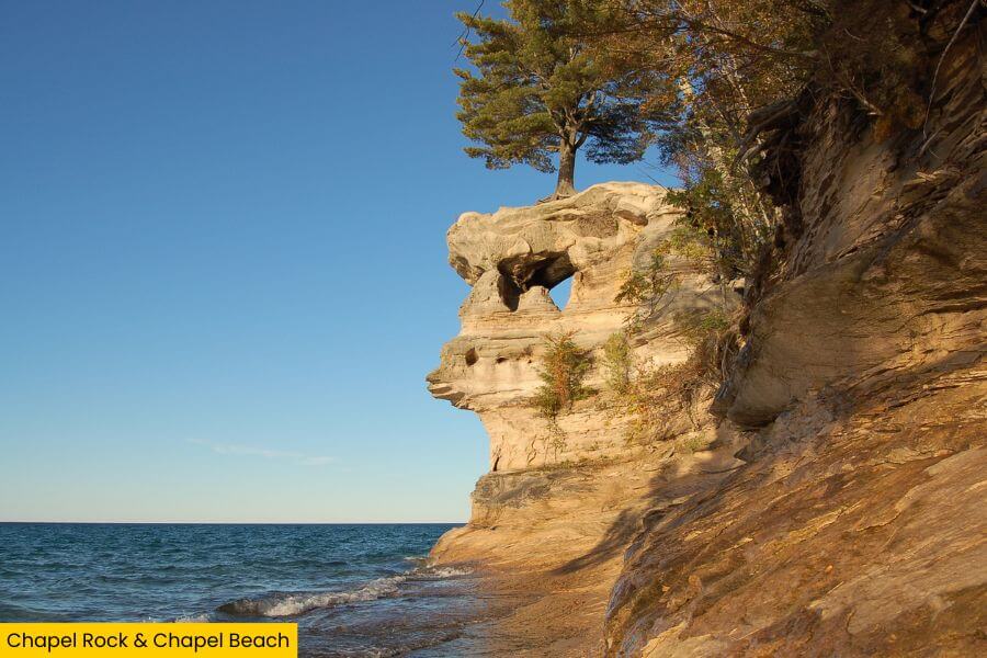
Once you’re back at the Chapel parking lot, follow the trail to Chapel Rock and Chapel Beach, one of the most eye-catching shoreline areas in the park.
The full hike is about 6.2 miles round trip, ending at a white pine tree perched on Chapel Rock, with roots stretching through the air to reach the mainland.
That natural “bridge” of roots is the star of the show, especially since erosion separated the rock from the cliffs, leaving the tree somehow still alive.
And just below, Chapel Beach gives you a wide stretch of crashing Lake Superior waves, making it the perfect place to unwind and soak up the view.
6. Twelvemile Beach
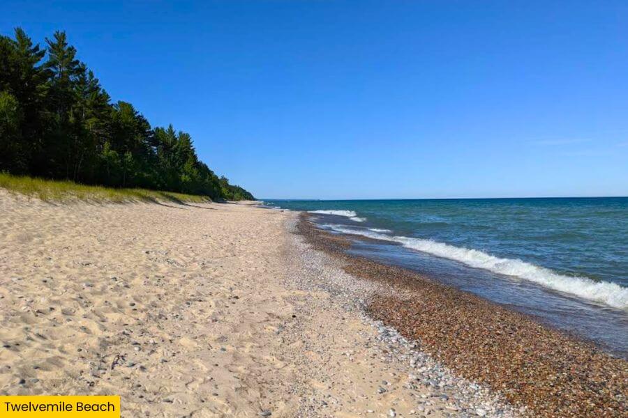
Then there’s Twelvemile Beach, a 12-mile stretch of shoreline that feels completely different from the cliff-lined areas you just explored.
It has a mix of sand and smooth stones, creating an ideal setting for a long walk with nonstop lake views.
You can access it from several points, but the easiest is from Twelvemile Beach Campground, with a short walk and a set of stairs leading down from the bluff.
Stick around for sunset if you can, because the open horizon over Lake Superior fills with shades of orange and pink for a picture-perfect moment.
7. Au Sable Light Station
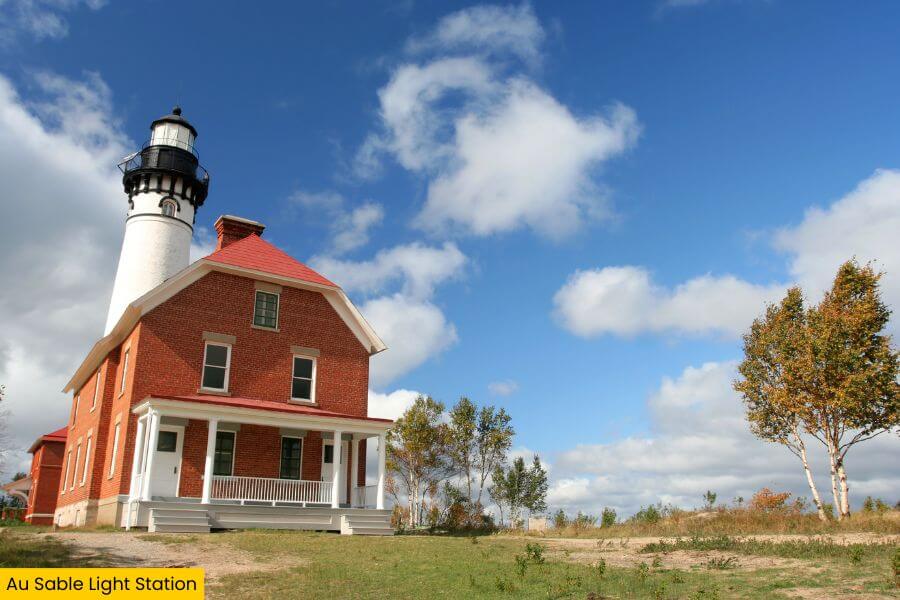
Finish your route with the Au Sable Light Station, a historic lighthouse set on Au Sable Point along the south shore of Lake Superior.
You’ll hike a 3.1-mile out-and-back along the North Country Trail from Hurricane River Campground to reach it, with steady lake views along the way.
During summer, you can join a guided tour to explore the keeper’s quarters and climb the tower for sweeping views, or just relax on the nearby beach.
Cool fact: The lighthouse was built in 1874 and stands 86 feet tall, once guiding ships through this stretch of shoreline known for frequent shipwrecks.
Related Posts