The Smoky Mountains are basically a giant invitation to get outside and explore.
We’re talking trails that lead to wildflower-filled meadows, roaring waterfalls, rocky cliffs with gorgeous views, and even towers where you can see for miles.
Some hikes are quick leg-stretchers, others will have you huffing and puffing all day, but every single one comes with a big payoff.
If you’re ready for sweeping panoramas, hidden history, and unforgettable moments, these 9 trails need to be at the very top of your bucket list.
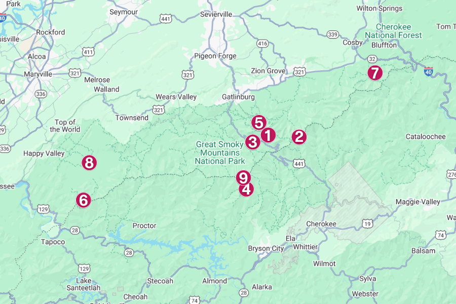
1. Alum Cave Trail to Mount LeConte
Length: 5 miles one way (10 miles round trip)
Difficulty Rating: Strenuous

Alum Cave Trail starts on Newfound Gap Road and climbs up to Mount LeConte, the park’s third-highest peak at 6,593 feet.
Along the way, you’ll pass through Arch Rock, a natural stone tunnel, and then reach Alum Cave Bluffs, an 80-foot-high overhang that’s not actually a cave.
With about 2,700 feet of elevation gain, this trail will test your legs, but the views of Little Duck Hawk Ridge and Myrtle Point make it worthwhile.
Fun fact: Before it became a hiking hotspot, the area was mined in the 1800s for alum, epsom salt, and saltpeter, which gave the trail its name.
2. Charlies Bunion via Appalachian Trail
Length: 8 miles round trip
Difficulty Rating: Moderate to strenuous

Sitting on the Appalachian Trail, Charlies Bunion is one of the park’s most stunning rock outcrops, offering views that stretch for miles.
The hike starts at Newfound Gap, climbing about 1,640 feet through spruce-fir forests before popping out onto the rocky cliff.
On clear days, you can spot Mount Kephart and the Sawteeth Ridge, while spring brings a display of blooming wildflowers.
Cool fact: The fun name comes from hiker Charlie Conner, whose swollen foot supposedly looked like this area (once you see it, you can’t unsee it).
3. Chimney Tops Trail
Length: 3.5 miles round trip
Difficulty Rating: Strenuous

Next up is Chimney Tops, a short but demanding hike with more than 1,300 feet of elevation gain in the first two miles.
You’ll zigzag up switchbacks, cross rushing streams on sturdy log bridges, and climb through lush hardwood forest before hitting the rocky summit area.
The actual rock pinnacles are now closed after a 2016 wildfire, but the new observation platform delivers views of Sugarland Mountain and Mount LeConte.
It’s the kind of hike where you’ll be sweating, smiling, and snapping way too many photos before you even hit the top.
4. Andrews Bald
Length: 3.6 miles round trip
Difficulty Rating: Moderate

Then there’s Andrews Bald, which rises 5,920 feet as the Smokies’ highest grassy bald, with views reaching Fontana Lake on a clear day.
The hike starts at Clingmans Dome parking area and follows Forney Ridge Trail, dropping 899 feet through spruce-fir forest into wide, flower-filled meadows.
In summer, the bald bursts with flame azaleas and Catawba rhododendron, turning the whole place into a wildflower wonderland.
Pack a picnic because this is one of the best spots in the park to plop down in the grass, kick back, and soak it all in.
5. Rainbow Falls Trail
Length: 5.6 miles round trip
Difficulty Rating: Strenuous

Moving from grassy meadows to cool mist, Rainbow Falls Trail climbs to the Smokies’ tallest single-drop waterfall at 80 feet high.
The trail begins just outside Gatlinburg, gaining 1,500 feet through rocky sections, stream crossings, and plenty of shady forest.
On sunny afternoons, the spray from the falls creates a shimmering rainbow, giving this iconic spot its name.
In winter, some parts of the cascade can freeze solid, forming jaw-dropping ice sculptures that will surely stop you in your tracks.
6. Gregory Bald
Length: 11.3 miles round trip
Difficulty Rating: Strenuous
 (1)")
Famous for its summer display of flame azaleas, Gregory Bald bursts with colors from neon orange to deep red that blanket the mountaintop each June.
The hike starts at the Gregory Ridge Trailhead and climbs 3,020 feet through hardwood forest before breaking out into the open bald at 4,949 feet.
On super clear days, you can see Cades Cove, Fontana Lake, and even the distant mountains of North Carolina all from one sweeping viewpoint.
It’s a long trek, so pack plenty of snacks and take your time enjoying the views from the top.
7. Mount Cammerer via Low Gap Trail
Length: 11.1 miles round trip
Difficulty Rating: Strenuous
 (1)")
Up next is Mount Cammerer via the Low Gap Trail, which climbs about 3,045 feet from Cosby Campground.
It winds through switchbacks, hardwood forest, and rhododendron tunnels before linking with the Appalachian Trail.
The payoff comes at 4,928 feet, where a stone fire lookout tower sits on a rocky summit with 360-degree views of the Pigeon River Gorge and Snowbird Mountain.
Built in the 1930s by the Civilian Conservation Corps, this octagonal tower still has its original windows and stone walls, making it feel like a piece of Smokies history.
8. Abrams Falls Trail
Length: 5 miles round trip
Difficulty Rating: Moderate

In Cades Cove, the Abrams Falls Trail leads you to a 25-foot waterfall with one of the most powerful flows in the Smokies.
The trail rolls up and down along Abrams Creek, passing rhododendron thickets, hemlocks, and even a few spots where you can stop for a break.
When you reach the end, you’ll see that the falls churn out a huge volume of water, creating a foamy pool that’s beautiful to look at but dangerous for swimming.
It’s an easy hike compared to the big mountain climbs, and the sound of that roaring cascade will stick with you long after you’ve left.
9. Kuwohi Observation Tower Trail (formerly Clingmans Dome)
Length: 1-mile round trip
Difficulty Rating: Moderate
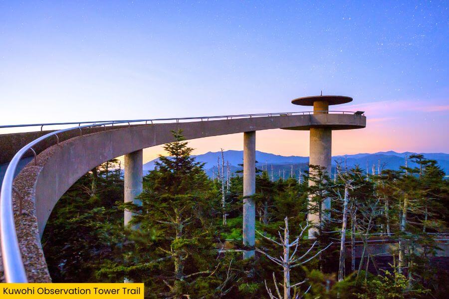
Rounding out the list is Kuwohi Observation Tower Trail, formerly known as Clingmans Dome, which reaches the highest point in the Smokies at 6,643 feet.
The paved trail climbs steeply from the parking area to a futuristic concrete ramp that spirals up to the tower’s viewing platform.
From the top, you can see as far as 100 miles on a clear day, with layers of blue-hued mountains fading into the horizon.
Tip: Bring a jacket, even in summer as the temps up here can be 20 degrees cooler than down in the valleys.
Related Posts