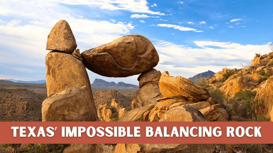
A giant rock is sitting on top of two narrow stone pillars in the middle of the Texas desert.
And somehow, it has not fallen over.
At first glance, it looks completely impossible.
The boulder seems way too big for the narrow columns holding it up.
It almost feels like the whole thing should crash down at any moment…but it hasn’t.
This strange rock formation has been standing like this while wind, rain, and blazing desert heat slowly shape the land around it over millions of years.
So how did it get there?
And more importantly, how is it still standing today?
Let’s take a closer look.
Where Is It?
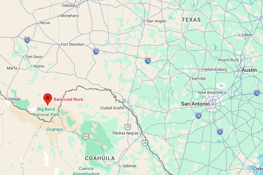
Balanced Rock is located inside Big Bend National Park in far West Texas, along the Grapevine Hills Trail near the park’s north entrance.
It’s located at the end of the Grapevine Hills Trail, with the trailhead being found on Grapevine Spring Road.
From Midland, the drive takes about 4 hours.
From El Paso, expect roughly 5 hours and 20 minutes on the road.
If you’re coming from bigger Texas cities like San Antonio, plan for about 6.5 to 7 hours.
From Austin, it’s about 7 hours and 45 minutes, depending on your route.
About

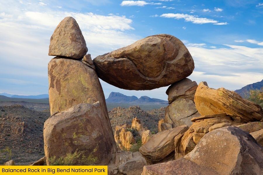
Balanced Rock is one of the most eye-catching rock formations in Big Bend National Park, and it looks almost impossible the first time you see it.
Picture a giant boulder perched on two narrow stone pillars, with open air beneath it and the desert stretching out around you, with rocky hills all around.
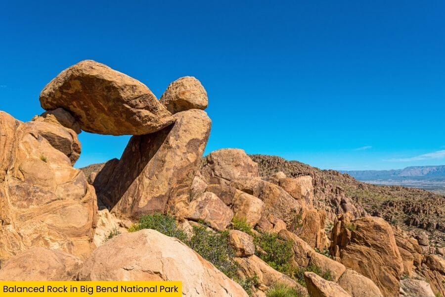
The rock itself is huge, with the massive capstone resting across two slim columns that look far too small to hold that much weight.
At first glance it feels like the whole thing should topple over with the next strong gust of wind.
Yet it has been shaped over millions of years through gradual erosion.
Balanced Rock sits inside the Grapevine Hills, a rugged collection of volcanic formations that formed over 30 million years ago when powerful eruptions shaped much of the Big Bend region.

Over time, layers of volcanic ash and lava hardened into thick rock.
Wind, rain, and temperature swings slowly chipped away at the surrounding stone through a process called erosion.
Softer rock wore away faster than the harder sections above it.
Eventually the surrounding rock eroded away, leaving the large rock balanced atop the upright slabs you see today.
The tougher caprock stayed mostly intact, leaving the huge boulder perched like a natural balancing act.
This kind of formation is sometimes called a balanced rock, and it forms when uneven erosion sculpts rock into strange shapes over long stretches of time.
The result is one of the most recognizable natural landmarks in Big Bend.
Standing near it gives you a real sense of scale.
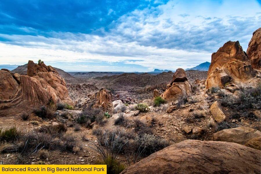
Balanced Rock rises from a maze of tumbled boulders, volcanic rock formations, and rust-colored cliffs that make the Grapevine Hills feel almost like a giant natural sculpture garden.
Huge blocks of rock lie scattered across the desert floor, stacked and tilted in ways that look completely random.

Some are as large as small houses while others form narrow passages and shady pockets between the cliffs.
Because of the wide open desert around it, the rock stands out clearly against the sky.
Sunrise and sunset are especially striking.
The stone glows deep shades of orange and red as the low sun hits the cliffs and boulders.
On clear days you can also see distant mountain ranges rising along the horizon, adding to the sense that you are standing in a remote corner of Texas.
How To See It
To reach Balanced Rock, you’ll take the Grapevine Hills Trail, one of the most popular short hikes in Big Bend National Park.
The trail begins at the Grapevine Hills Trailhead, located along Grapevine Springs Road.
From the parking area, the hike to Balanced Rock is about 2.2 miles round trip.
 (1)")
Most people complete it in 1 to 1.5 hours, depending on how long they spend exploring the rock formations at the end.
The first section of the trail is fairly easy.
You’ll walk across a wide desert wash with a sandy and rocky surface while low desert plants spread out across the landscape.
Look around and you’ll spot classic Chihuahuan Desert vegetation like creosote bushes, lechuguilla, and prickly pear cactus.
The trail here is mostly flat and easy to follow, but the final section becomes steeper and rocky, requiring some scrambling.
 (1)")
Near the end of the trail, the terrain starts to change.
The path narrows and begins climbing gradually into the boulder field.
Massive rock formations tower overhead, some stacked in layers that look like giant blocks dropped into place.
The trail winds between these formations and begins gaining elevation more quickly during the final stretch.
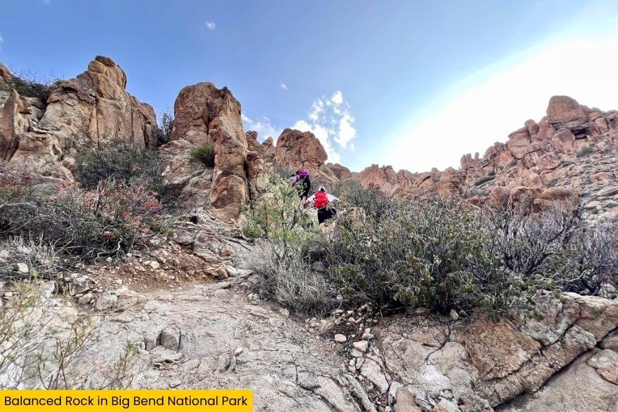
The last 0.25 miles involve a short but steeper climb up uneven rock steps.
You’ll scramble up smooth stone slabs and squeeze between boulders as the trail leads into a natural rock corridor.
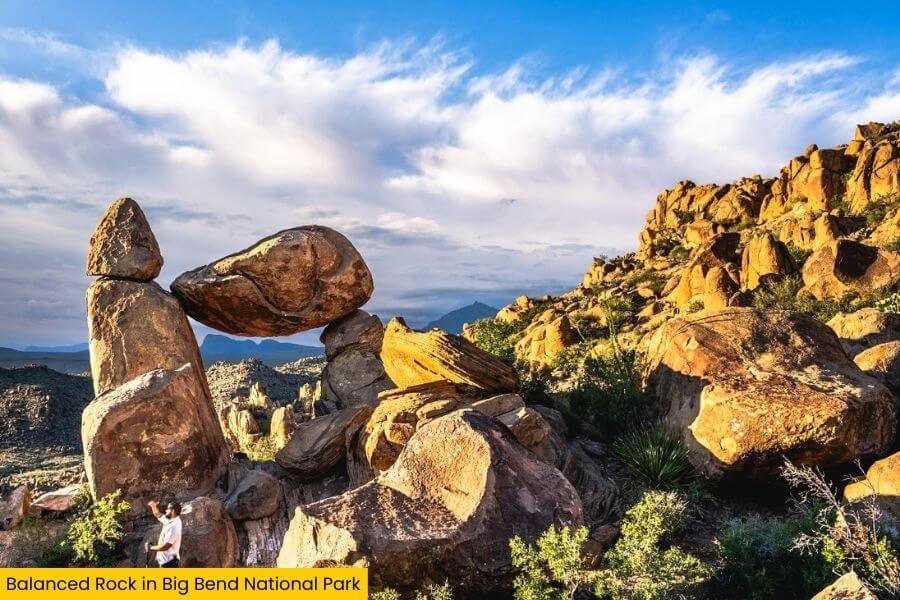
Balanced Rock rests among a cluster of large boulders in the Grapevine Hills, overlooking the surrounding rocky terrain.
From the viewing area, you can walk around the base of the formation and get different angles of the giant capstone resting across its two columns.
Many visitors like to climb slightly higher onto the nearby rocks for photos.
 (1)")
From these higher spots, you get wide views across the Grapevine Hills and out toward the distant desert mountains of Big Bend.
You can spend time exploring the surrounding rocks, finding different viewpoints, and watching how the colors of the stone change in the shifting sunlight.
Know Before You Go
Big Bend National Park is open 24 hours a day, year round.

The park charges an entrance fee of $30 per vehicle, and the pass is valid for 7 consecutive days.
If you plan to visit several national parks during the year, the America the Beautiful Annual Pass costs $80 and covers entry to all U.S. national parks and federal recreation areas.
The best time to visit is from October through April.
During these months, daytime temperatures in Big Bend usually range from 60°F to 80°F, which makes exploring the desert far more comfortable.
Summer can be extremely hot.
From May through September, afternoon temperatures often climb above 100°F, especially in the lower desert areas of the park.
Early morning or sunset visits are the most pleasant during warmer months.
Balanced Rock also looks especially dramatic in the late afternoon and at sunset.
Clear skies are common in Big Bend, so sunset light can be incredible for photos.
If you enjoy night skies, stick around after dark.
Big Bend National Park is one of the largest Dark Sky Parks in the world, covering more than 800,000 acres with extremely low light pollution.
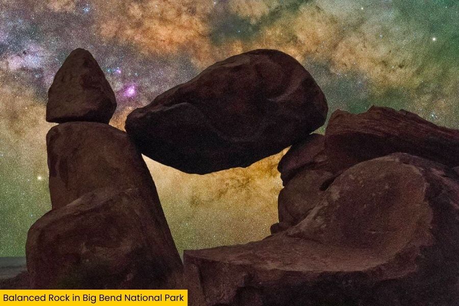
On clear nights you can easily see the Milky Way stretching across the sky with thousands of visible stars.
While you are in this area of the park, there are several other great stops nearby.
The Fossil Discovery Exhibit is less than a 15-minute drive away.
It features outdoor displays explaining the ancient animals that once lived here, including a giant flying reptile, Quetzalcoatlus northropi, with a wingspan of about 36 to 39 feet.
For another scenic hike, check out the Lost Mine Trail in the Chisos Mountains.
This 4.8 mile round trip trail climbs about 1,100 feet and rewards you with sweeping views of Juniper Canyon and Casa Grande Peak, which rises 7,325 feet above sea level.
 (1)")
If you want a scenic drive, take Ross Maxwell Scenic Drive to reach the Santa Elena Canyon Trail and viewpoint on the park’s western side.
The canyon walls there rise up to around 1,500 feet above the Rio Grande, creating one of the most famous views in Big Bend.
Cell service is extremely limited throughout Big Bend, so it helps to download maps ahead of time or carry a physical map with you.
Bring plenty of water while exploring the desert.
The dry climate and intense sun can cause dehydration quickly, even during cooler months.
Most hikers carry at least 1 liter of water per person for short hikes and more if spending extended time outside.
With its massive open landscapes, unusual rock formations, and some of the darkest night skies in North America, Big Bend delivers a desert experience that feels wonderfully remote and unforgettable.
Related Posts